Table of Contents
Get our free local reporting delivered straight to your inbox. No noise, no spam — just clear, independent coverage of Marblehead. Sign up for our once-a-week newsletter.
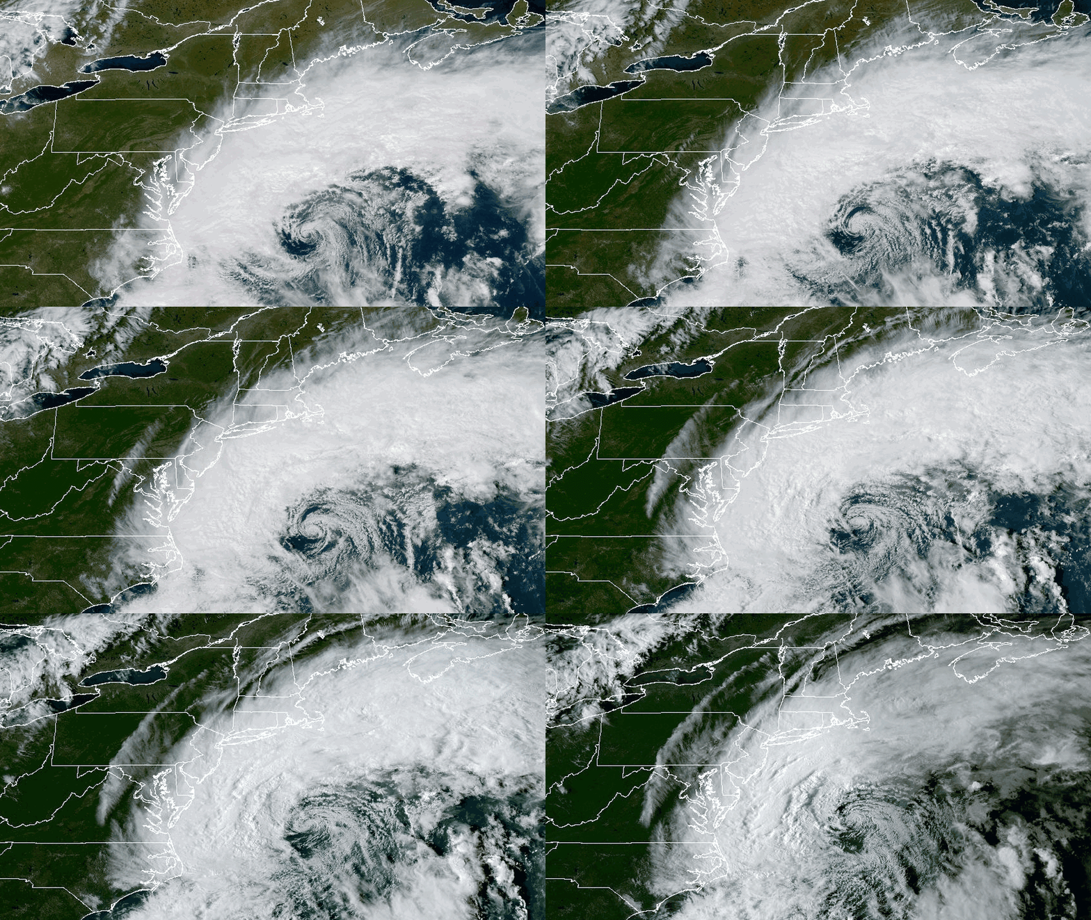
The National Weather Service upgraded Marblehead's coastal flood watch to a warning Friday, as a slow-moving nor'easter began pushing strong northeast winds, large waves and rising tides into the town's waterfront.
The warning, issued at 12:35 p.m., runs from 5 p.m. Friday to 8 p.m. Sunday for eastern Essex County. Forecasters expect up to 1 foot of water above ground level in low-lying areas near shorelines and tidal waterways, with minor flooding and pockets of moderate flooding over several high tides.
The weather service also extended the high wind warning for the eastern Massachusetts coast, which now runs until 8 a.m. Sunday, six hours later than first announced. It calls for northeast winds of 20 to 30 mph with gusts of 50 to 60 mph. Forecasters warned that damaging winds will bring down trees and power lines and that outages are expected.
The Marblehead Municipal Light Department said its crews are watching conditions and are ready to respond if the storm damages the town's electric system. Residents who lose power while the department's offices are closed, or who come across damaged electrical equipment, should call its 24-hour emergency line at 781-631-0240. The department warned residents to stay away from downed wires and never to touch one.
You're the reason this coverage exists. As the storm moves in this weekend, the Marblehead Independent will track the causeway, the waterfront and the tides for you, using forecasts from the National Weather Service and notices from the town. You can help in two ways. If you see flooding, downed trees or road closures, send us a photo and tell us where and when you took it, as long as you can do it safely from a distance. Send to wdowd@marbleheadindependent.com
The causeway and the waterfront
The town has flagged Front Street, Beacon Street and the Grace Oliver's area as places to watch for flooding and temporary road closures. The notice was posted Thursday and updated Friday morning.
The biggest concern for many residents is the Neck. Ocean Avenue and the causeway are the only road in and out of Marblehead Neck, and the town said it may close them if flooding, crashing waves or debris washing over the road make the crossing dangerous. Neck residents were told to plan for that possibility and avoid unnecessary trips during the height of the storm.
Town officials said road closures could come with little notice. They also warned that emergency crews may take longer than usual to respond if flooding, fallen trees or blocked roads get in the way.
Tides to watch
The weather service's latest tide forecast points to the weekend's late-night and midday high tides as the most dangerous.
At Boston Harbor, the nearest official gauge in the forecast, the high tide around midnight Saturday is forecast to reach up to 12.9 feet, above the 12.5-foot minor flood mark. The midday tide Sunday could reach 12.8 feet. Both tides are rated for minor flooding. At Gloucester Harbor, the same two tides are forecast at up to 11.7 feet, just over that station's 11.5-foot threshold.
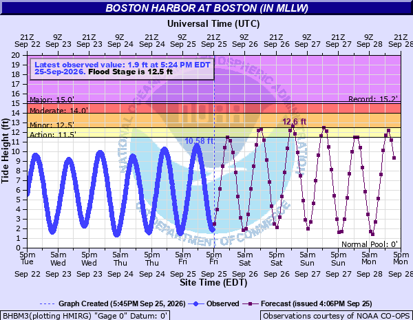
Forecasters said in a Friday afternoon discussion that storm surge of 1 to 2 feet, briefly near 2.5 feet, is expected along east-facing, ocean-exposed beaches. With seas of 15 to 25 feet offshore and astronomical tides climbing through the weekend, the weather service said flooding and erosion will remain a concern even as the wind begins to ease. Water may also struggle to drain between high tides.
The weather service said the greatest coastal flood risk appears to be setting up south of Boston and on Cape Cod and the islands. Along Marblehead's shoreline, it expects breaking waves of 6 to 13 feet through Sunday evening, down from the 17 feet forecast Thursday. It warned of severe beach erosion over a prolonged period and said the erosion may prove to be the storm's biggest impact.
Wind peaks Saturday
The weather service's forecast for Marblehead calls for gusts up to 38 mph Friday night, rising to 52 mph on Saturday. Gusts to 49 mph are forecast for Saturday night and 48 mph on Sunday before easing Sunday night.
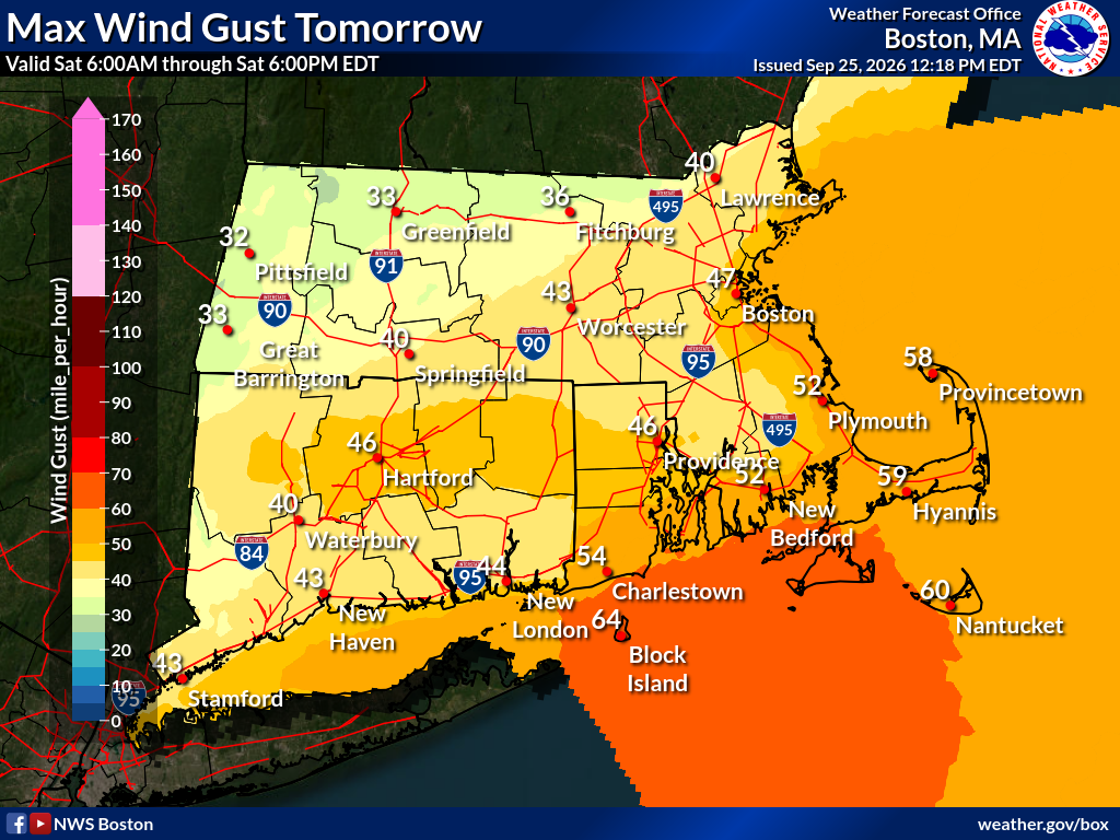
Forecasters said the track shifted southwest over the past day, moving the strongest winds farther west. They said the long duration of the wind, the heavy rain and trees still in full leaf matter more than whether any one spot reaches warning-level gusts. They called the storm unusually strong for September.
The town urged residents to secure outdoor furniture, trash containers and decorations, charge phones and stock emergency kits for a power outage that could last several days. It also reminded residents to run generators outdoors, at least 10 feet from any building.
Rain through Monday
The weather service's forecast for Marblehead adds up to about 4 inches of rain from Friday evening through Monday night. Forecasters said the heaviest rain should begin Saturday afternoon and continue through Monday.
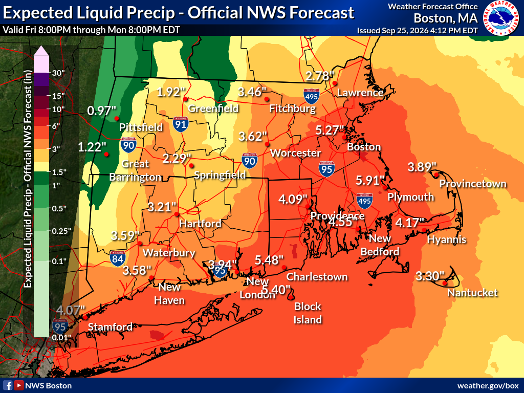
Across the region, forecasters expect 2 to 4 inches, with isolated totals of 5 to 6 inches possible, the higher amounts most likely near the coast. The weather service did not issue a flood watch because the rain is spread over several days, but said it is watching whether those heavier totals concentrate in any one area.
What comes next
The storm is expected to weaken slowly early next week. Forecasters said Tuesday will be one more wet, unsettled day before drier, warmer weather arrives.
The town told residents to stay off seawalls, beaches and rocks during high surf, to avoid parking in areas that flood and to obey all barricades. Updates on road closures, the Ocean Avenue causeway and power outages will go out through MarbleheadAlerts and the town's social media accounts.
When the causeway floods or the power goes out, you need news about Marblehead, not all of Massachusetts. The Marblehead Independent is covering this storm street by street, and it's free to read because members pay for it. If this story helped you get ready, become a member today and help keep independent local reporting going through this storm and the next one. Click here to become an Independent member.