Table of Contents
Get our free local reporting delivered straight to your inbox. No noise, no spam — just clear, independent coverage of Marblehead. Sign up for our once-a-week newsletter.
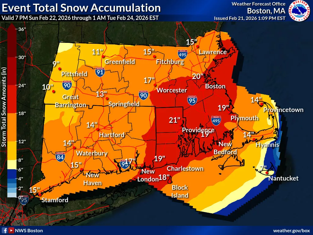
In what could become the fourth significant snow event to hit the town in less than two months, the National Weather Service issued a blizzard warning Saturday for eastern Essex County and much of eastern Massachusetts, warning residents to prepare for 1 to 2 feet of snow, wind gusts up to 60 mph and potentially life-threatening whiteout conditions beginning Sunday afternoon.
The warning, which upgrades a previously issued winter storm watch, takes effect at 4 p.m. Sunday and remains in place until 7 a.m. Tuesday. Forecasters said they have high confidence in snowfall totals of 10 to 20 inches across the region, with the heaviest snow expected to arrive Sunday after 10 p.m. and continue into Monday afternoon. Snowfall rates of 2 inches or more per hour are anticipated during the storm’s peak.
The weather service urged residents to restrict travel to emergencies only during the warning period, a sharp escalation from advisories earlier in the week. Visibility could drop below one-quarter mile due to falling and blowing snow, and forecasters said whiteout conditions would make driving treacherous and potentially life-threatening. Both the Monday morning and evening commutes fall within the warning window.
Northeast wind gusts of 40 to 60 mph are forecast across eastern Massachusetts and Rhode Island, creating the blizzard conditions that prompted the upgraded warning. The combination of heavy, wet snow and strong winds raises the risk of downed tree limbs and power lines, and the weather service said power outages are possible across the region.
Marblehead’s coastline faces an additional threat. The weather service issued a coastal flood watch for eastern Essex County effective from late Sunday night through Tuesday morning. Low-lying areas near shorelines and tidal waterways could see 1 to 2 feet of inundation above ground level. Nearby Gloucester Harbor is forecast to reach minor flood stage during the Monday morning high tide cycle, with wave heights of 8 to 13 feet. Roads near the waterfront could become impassable, and forecasters warned residents not to drive around barricades or through water of unknown depth.
The storm is part of a broader system that the weather service’s Boston office described Saturday as a “high impact winter storm.” The blizzard warning covers a wide swath of the region, stretching from the North Shore through Boston and south to Providence, Rhode Island. Northern Connecticut, further from the coast, is under a winter storm warning with 12 to 18 inches of snow expected but lower wind speeds.
Conditions in Marblehead on Saturday afternoon were calm ahead of the storm. The Beverly Municipal Airport reported overcast skies, a temperature of 27 degrees and light northeast winds of 7 mph as of 1:53 p.m. Sunday is expected to be cloudy with highs in the mid-30s before snow moves in during the evening hours.
The weather service advised anyone who must travel during the storm to carry a winter survival kit and to stay with their vehicle if stranded. Residents in flood-prone areas along the coast should take steps to protect their property before the storm arrives.
The storm is expected to clear by Tuesday, with partly cloudy skies and highs in the lower 30s. Another chance of snow and rain returns Wednesday.


