Table of Contents
Get our free local reporting delivered straight to your inbox. No noise, no spam — just clear, independent coverage of Marblehead. Sign up for our once-a-week newsletter.
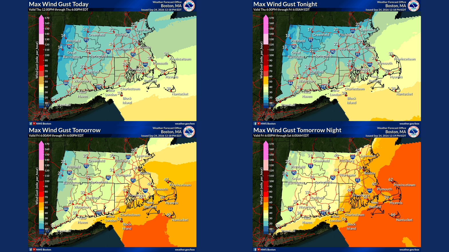
Marblehead faces damaging wind gusts of up to 60 mph, breaking waves as high as 17 feet and possible coastal flooding this weekend as an early-season nor'easter moves up the East Coast, according to the National Weather Service.
The weather service on Thursday at 12:38 p.m. upgraded its alert for eastern Essex County, which includes Marblehead, to a high wind warning. It runs from 8 a.m. Friday to 2 a.m. Sunday. Forecasters expect northeast winds of 25 to 35 mph, with gusts of 45 to 60 mph.
The same stretch of coast is under a high surf advisory from 5 a.m. Friday to 8 p.m. Sunday. A coastal flood watch covers Friday afternoon through Saturday afternoon.
While the storm will bring offshore winds to the Mid-Atlantic, winds along coastal New England will blow onshore as the system strengthens, Bob Oravec, a senior meteorologist with the weather service, told The New York Times.
Water with nowhere to go
The flood watch warns of up to 1 foot of water above ground level in low-lying areas near shorelines and tidal waterways. The weather service said numerous roads may close and that homes, businesses and some critical infrastructure could be inundated.
The two tide stations nearest Marblehead in the weather service's forecast show how narrow the margin is. Water levels there are measured against the average of the lowest daily tides. At Gloucester Harbor, the Friday night high tide, around 11 p.m., is forecast at up to 11.3 feet, just shy of the 11.5-foot minor flood mark. At Boston Harbor, the same tide is forecast at up to 12.4 feet, against a 12.5-foot threshold. The weather service's Boston Harbor forecast graph shows a weekend peak near 12.8 feet, just above that line.
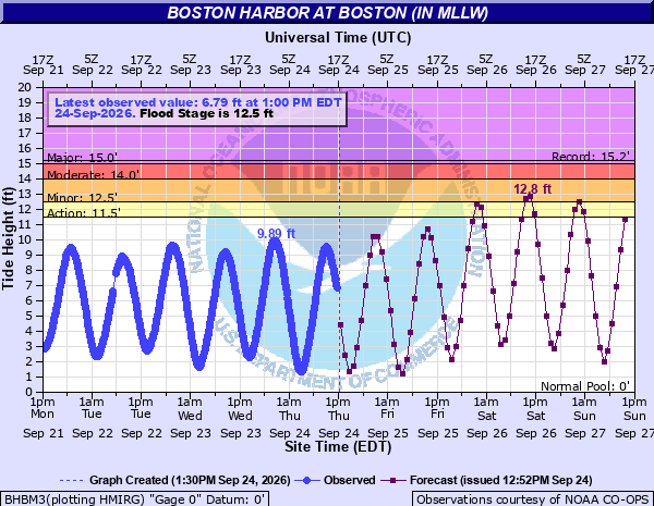
Timing will decide which side of the line the water lands on. Forecasters said the exact arrival of the coastal low remains uncertain, and that matters most for surge around high tide. Several tide cycles will be affected, and strong onshore winds could keep water from draining between them.
High tides on Friday and Saturday occur just before midnight, the two cycles that coincide with the strongest onshore winds. The storm also coincides with Saturday's full Harvest Moon, which will produce astronomically high tides.
The surf advisory calls for breaking waves of 6 to 17 feet. At Gloucester Harbor, forecast wave heights climb to 14 to 16 feet Friday night and 16 to 17 feet by midday Saturday.
Forecasters flagged beach erosion as a concern, mainly for east-facing beaches. They told inexperienced swimmers to stay out of the water and warned drivers not to go around barricades or through water of unknown depth.
Trees still in full leaf
The weather service's Thursday forecast maps show gusts in the low 50s along the coast from Cape Ann to Boston between Friday evening and Saturday morning. The forecast for Boston is 51 mph.
The calendar works against the trees. Forecasters said the long stretch of wind, heavy rain and fully leafed branches raises the risk of downed trees and power lines, and the warning states plainly that outages are expected. The weather service urged residents to secure loose objects before the wind arrives.
The weather service's official forecast shows about 2.4 inches of rain for Boston through 8 a.m. Sunday, with higher totals to the south and east. Oravec told The Times that Cape Cod and the islands could see 5 to 7 inches.
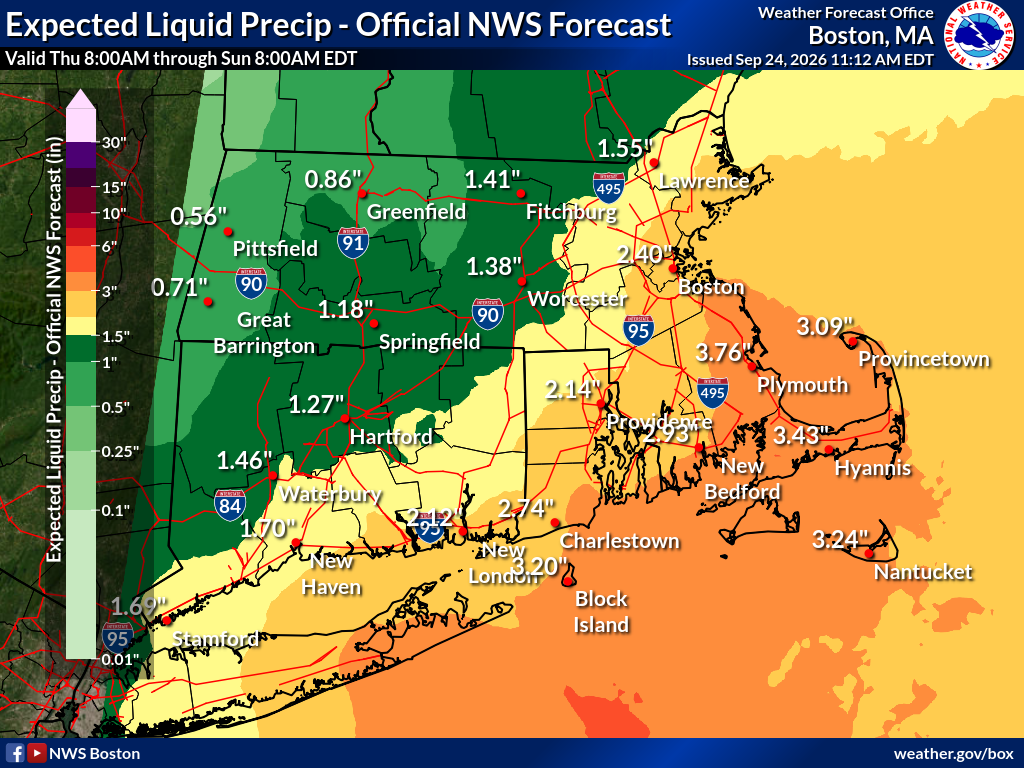
Those numbers could shift. Forecasters said the storm's exact track remains the biggest unknown. Some computer models show the storm looping back to the west, which would spread heavier rain inland. Others keep it far enough offshore to cut totals sharply.
Slow to leave
The storm is expected to weaken Sunday and Monday, but it will be slow to move out. Oravec told The Times that eastern New England may not see the sun again until Tuesday.
It may not be the last storm of its kind this season. Meteorologists told The Times that a developing El Niño pattern is likely to push several more storms up the East Coast in the coming months.
Storm coverage is local infrastructure, too. The Marblehead Independent tracks the forecasts, warnings and local impacts so you can understand what is coming and what it could mean here. If you value timely local reporting and a newsroom that stays with the story as conditions change, join us this week. 🟦 Become a member here.